June 27-28th, 2009 -- Port Jefferson NY to Newport RI
When I went to sleep in Port Jefferson after the exciting day passing through New York harbor I was hoping to make it all the way to Newport the next day. However, as often happens on a cruise, the weather controls the day and I awoke socked in with heavy fog-- I couldn't even see the beach or the breakwater that I had anchored near the night before.I checked the weather forecast and they claimed the fog would burn off early in the morning so I relaxed on the upper deck and caught up on this blog and chatted with Marianne on the cell phone-- much easier to single-hand when I know my love is a quick phone call away!
By 8 am it looked like the fog was lifting so I raised anchor and left the harbor-- only to find that the fog closed in again and I was surprised how easy it was to became disoriented. My GPS seemed to be misbehaving and at one point I saw my depth sounder ticking down and I realized I was headed towards the beach! A quick 180 turn to deeper water and I decided to slowly pick my way back into the harbor and drop anchor again for a couple of hours.
 |
| Looking ahead in heavy fog |
Traveling in the fog is tense-- you hear a fog horn in the distance but you're not sure from where it comes because the fog distorts the direction. You see blips moving on the radar but you're worried a sailboat without a radar reflector might be right in front of you. You watch the AIS screen for larger ships but many boats don't broadcast an AIS location. You watch the GPS chart plotter to make sure you are on track in safe waters. You watch your depth sounder to make sure your depth matches the chartplotter. You stare ahead at the white cloud of fog with your hand on the throttle to throw the engine into reverse and say a prayer. At one point I saw a blip on the radar coming directly towards me about a mile away. I turned 60 degrees starboard to pass safely and watched at the blip also changed course still aiming for me about now about 600 yards away! I called a warning on the VHF channel 16 and turned starboard another 45 degrees and incredibly, watch the blip still coming towards me. I blasted my horn 5 times in the international danger signal and finally saw the blip turn away from me. The radar showed it passing about 75 yards from me-- I heard a loud engine but never saw the boat through the fog!
 |
| The entrance buoy appears in the fog |
The fog stayed with me all day so I was close to sunset as I approached Block Island. I kept watching for the red entrance buoy to the Great Salt Pond. The GPS chart plotter showed that the buoy was less than 100 yards away and I could hear it but couldn't see it. I crept closer and finally saw the buoy appear out of the fog. As I entered the channel the fog lifted completely and it was a perfect sunny evening!
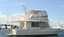
 I dropped anchor in New Harbor at Block Island-- one of our favorite trips from our home port of Newport. We love Newport-- the constant parade of huge yachts, the America's Cup 12 metre yachts racing each other, the cruise ship tenders dropping passengers off to tour the mansions-- there isn't another harbor like it!
 |
| Aldos Bakery boat delivering to the anchorage |
The next morning I woke early for the short trip to Newport. I crossed our wake about 10 am off Point Judith-- 18 months and 5,000 miles!
As I came around Goat Island and headed for our mooring I could see Marianne waiting for me with several of our children and grandchildren. Home at last!


 Several people had told us not to miss Yorktown-- about a four hour cruise from Portsmouth. The National Park Service had recently worked on the restoration of this colonial town where the British surrendered to George Washington ending the Revolutionary War. As we got close to the town we could see the monument to the victory.
 ... and the statue commemorating the surrender ceremony...
 There is a marina on the riverfront that is very close to the town and on the route of the free shuttle that runs from the river to the battleground. Yorktown was a major port prior to the revolution partly because the river is so deep near the shore that large ships could easily unload on the wharf. In the picture below of Pathfinder at the marina, the water is 55 feet deep!
 We spent two relaxing days in Yorktown and had the time to explore the battlegrounds and visitor centers. However, the wind shifted the second day and the boats in the marina were rocking and rolling with the waves. We decided to get an early start after the second night and left in foggy weather to head up the Chesapeake.
 As we moved down the York river, the fog began to burn off but the waves picked up. The weather forecast was for one foot waves but we found ourselves heading into 3-4 foot seas with spray almost up to the bridge. We slowed down a bit so we wouldn't pound into the waves. Luckily, the seas settled down after about an hour and we turned into Reedville about noontime. We had planned to anchor for the night but found that there was no cellphone coverage for the conference call I had the next morning. By this time the weather was beautiful-- sunny with gentle winds -- so we decided to push on to Solomons Island. We knew this would end up being an eleven hour cruising day... but it would be nice to settle into a great marina for a few days. We arrived at the Spring Cove marina at 6pm and settled into the same slip we had occupied in 2007.
 We decided to stay in Solomons Island for three days... a chance to get caught up on laundry, restock supplies at the nearby supermarket, enjoy some great meals at the local restaurants, and relax in the olympic-size pool.
  On Saturday we left for the 50 mile trip to St. Michaels-- one of the prime cruising spots in the Chesapeake. The cliffs behind the Cove Point lighthouse were beautiful in the morning light.
 Our plan is to spend several days in St. Michaels then move on to Annapolis... we'll have a lot to tell you on the next entry!


 These large bodies of water can get quite rough so we were happy the weather was still with us.


 The next morning, May 23rd, we only had a short 30 mile trip to Coinjock, kind of a rest area on the ICW! Boats just pull over to the side of the narrow ICW and tie to a long dock. The attraction at Coinjock is a good restaurant famous for its 32 oz prime rib dinner. Chris ordered it and had plenty left over for another dinner the next day!